

Field Note: Ahu Huri a Urenga — Architecture, Astronomy, and an Open Question
There are monuments that seem to invite certainty.
Ahu Huri a Urenga is not one of them.
Situated inland on an elevated ridge southeast of Hanga Roa, near the red-scoria quarry of Puna Pau, the monument differs in several respects from many of Rapa Nui's coastal ceremonial platforms. Its position, architecture, and orientation have made it one of the island's most discussed archaeological sites, yet many of its most distinctive features remain unresolved.
Rather than presenting conclusions, this field note documents observations from the site alongside the current archaeological record, distinguishing between evidence, published interpretation, and questions that remain open.
Field Observation
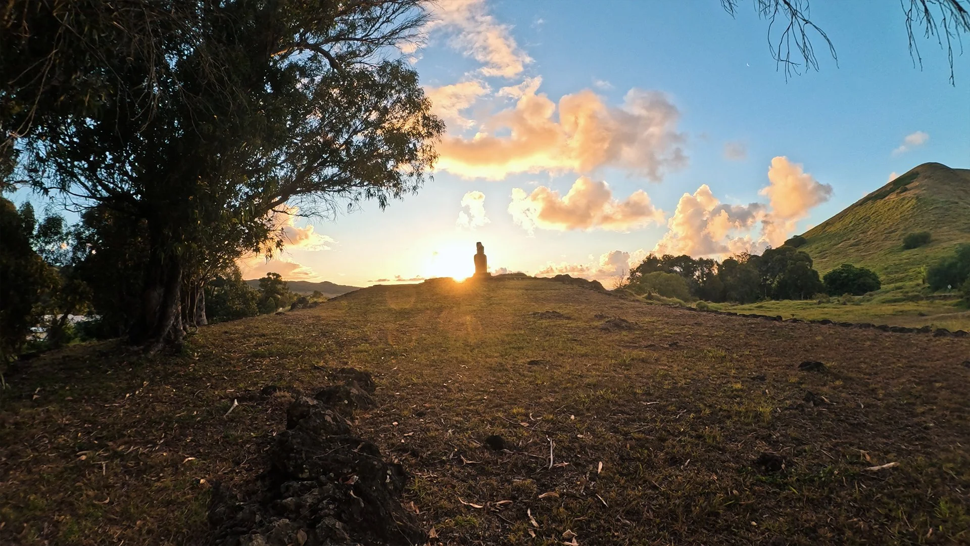
Ahu Huri a Urenga occupies a commanding inland position between coastal zones. The restored platform measures approximately 12.4 metres long and 3.6 metres wide and supports a single standing moai.
Immediately east of the platform lies an unusually long trapezoidal plaza. Unlike most Rapanui ceremonial plazas, this one is enclosed by retaining walls on all sides, including the eastern end opposite the platform. The plaza descends eastward in two distinct planes, while the platform itself is rotated approximately thirty degrees relative to the plaza's principal axis.
Rows of rounded beach boulders form the ceremonial ramp leading away from the platform. Smaller beach pebbles fill the spaces between them, with a separate pavement of carefully selected flat stones farther east. The nearest shoreline lies more than two kilometres away, meaning hundreds of beach stones were intentionally transported inland.
North of the plaza is a large rectangular paved structure built from carefully selected flat stones bordered by upright slabs. Nearby is a raised lateral terrace. Farther west stands the reconstructed remains of a traditional avanga, or crematorium.
During several weeks documenting domestic architecture across Rapa Nui, I observed numerous cooking areas associated with habitation sites. These consistently displayed similar construction methods, scale, and relationships to adjacent house foundations. The large rectangular paved feature at Ahu Huri a Urenga differs markedly in construction, setting, and scale. While observation alone cannot determine its function, it appears architecturally distinct from ordinary domestic food-preparation areas.
During sunset filming, the descending sun passed directly behind the moai's head and torso when viewed from the trapezoidal plaza. A crescent moon appeared to the right of the monument later that evening. These observations record the monument's interaction with the sky but should not be interpreted as evidence of intentional alignment without supporting measurements.
The Archaeological Record
William Mulloy's restoration and excavation of Ahu Huri a Urenga between 1972 and 1973 remains the principal archaeological investigation of the site.
His preliminary Bulletin 3 documented the excavation and restoration work but deliberately avoided broader interpretation. The later 1975 publication expanded substantially on these findings, adding architectural measurements, artifact analysis, radiocarbon dating, astronomical discussion, and consideration of the site's mortuary features.
One of Mulloy's most important observations concerns the moai itself.
Although the monument is frequently described as the island's only "four-handed" moai, Mulloy argued that the apparent second pair of hands likely resulted from a later recarving. The original hands and hami (breechcloth) were carved asymmetrically and later reworked into a more central position. Because the earlier carving was never completely removed, traces remain that create the appearance of four hands.
Whether this explanation ultimately proves correct remains open to discussion, but it currently represents the strongest published archaeological interpretation.
The monument also preserves evidence of multiple mortuary contexts.
Excavations identified later burials north of the platform, deposits of cremated human bone, a lateral terrace containing burned bone fragments, and a reconstructed western crematorium. These represent separate archaeological contexts rather than a single ritual event.
North of the plaza, Mulloy documented the large rectangular paved structure often described today by guides as a "kitchen." He did not identify it as such. Instead, he recorded its function as unknown while noting similarities to another paved platform at Vinapu that an island informant had identified as a place where bodies were dried prior to cremation.
The archaeological evidence therefore points toward a specialized ceremonial landscape rather than an ordinary domestic setting.
Architecture and Astronomy
Ahu Huri a Urenga has long attracted attention because of its apparent astronomical orientation.
Mulloy measured the platform's western perpendiculars at approximately 243–244 degrees true azimuth, corresponding closely with the setting sun near the southern summer solstice and, in the opposite direction, the winter-solstice sunrise.
North of the plaza, five cup-shaped cavities carved into exposed bedrock form a possible solar ranging device. Mulloy compared these features with similar installations documented at Orongo and suggested they may have assisted observations associated with solstices and equinoxes.
He remained appropriately cautious.
The monument had undergone substantial restoration before final measurements were taken, and he emphasized that direct astronomical observation remained necessary before intentional alignment could be confirmed.
Subsequent work by Edmundo Edwards and Juan Antonio Belmonte similarly argued that astronomical alignment requires measured azimuths, horizon correction, and statistical evaluation rather than visual impression alone.
During my visit, archaeologist Edmundo Edwards described the monument as potentially oriented toward the heliacal rising of Matariki (the Pleiades) near the June solstice. Across Polynesia, the heliacal rising of Matariki commonly marks seasonal transition and agricultural renewal.
Whether Ahu Huri a Urenga served such a function remains an open question requiring further measurement.
Time, Authority, and Observation
If future research confirms that the monument intentionally marks significant seasonal events, its importance extends beyond symbolism.
In small island societies, accurate seasonal knowledge supports agriculture, ritual scheduling, and communal coordination. The ability to recognize and communicate these transitions represents a form of practical authority.
This should not be confused with mystical power.
Calendrical authority refers to the capacity to organize communal life through reliable knowledge of seasonal change. Across Polynesia, astronomical specialists frequently occupied positions closely connected to chiefly authority because accurate timekeeping influenced planting, harvesting, and ceremonial life.
Whether Ahu Huri a Urenga fulfilled such a role remains uncertain. The archaeological evidence permits the question but does not yet answer it.
What Remains Unresolved
The strength of Ahu Huri a Urenga lies not in providing certainty but in resisting it.
The monument combines an unusual inland location, distinctive architectural planning, evidence of astronomical observation, multiple mortuary contexts, and one of the most discussed statues on the island. Yet each feature requires careful interpretation.
At present, the evidence supports neither mystical speculation nor definitive explanation.
Instead, it points toward a monument where architecture, landscape, celestial observation, and ceremonial practice appear to converge in ways that remain only partly understood.
For now, the most responsible conclusion is also the simplest:
Ahu Huri a Urenga remains one of Rapa Nui's most compelling open archaeological questions.
Continue Exploring
